
Detroit RiverFront Conservancy, City of Detroit and Detroit Economic Growth Corporation announce new plan to preserve and expand Riverfront access
“A RIVERFRONT FOR ALL: EQUITABLE, INCLUSIVE, AND ACCESSIBLE”
March 1, 2017 [DETROIT] – Officials from the Detroit RiverFront Conservancy (DRFC), the City of Detroit Planning & Development Department (PDD) and the Detroit Economic Growth Corporation (DEGC) announced the details of a framework plan that will preserve more riverfront land for public use and create greater community access. The plan, which also will lead to new investment and development opportunities within the East Riverfront, was unveiled during a community meeting this evening at the Outdoor Adventure Center, 1801 Atwater Street.
The Detroit RiverFront Conservancy, City of Detroit Planning & Development Department and the Detroit Economic Growth Corporation began working with Skidmore, Owings & Merrill (SOM) on a strategic framework plan for the East Riverfront in the spring of 2016. This announcement represents several months of residential and stakeholder engagement, which included community meetings, neighborhood walks and district tours that were attended by the general public. New York–based HR&A Advisors provided real estate and economic consulting services for the framework plan, and landscape design concepts were created by Michel Desvigne and Inessa Hansch, a world-renowned team of Paris-based designers, in collaboration with SOM and Detroit-area firms.
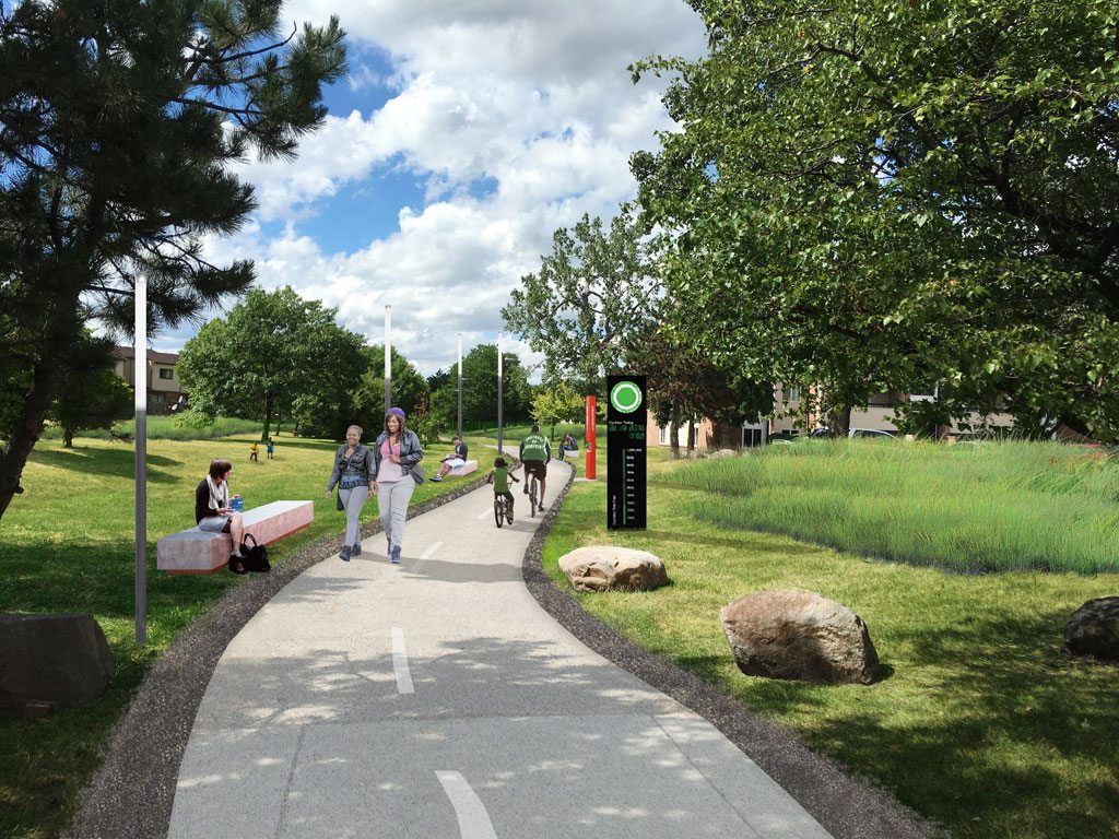
Improved Campau Greenway Concept. East Riverfront Renderings. Detroit RiverFront Conservancy
Six local firms—McIntosh Poris, Birmingham; Giffels Webster, Detroit; Kraemer Design Group, Detroit; AKT Peerless, Detroit; Rich & Associates, Southfield, and E. Austell Associates, West Bloomfield—provided significant consulting and advisory roles during the planning stages.
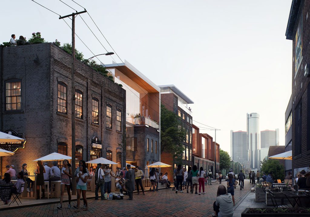
Under the plan, the East Riverfront area will continue to be transformed from a former blighted, industrial area into a vibrant waterfront for all Detroiters. The boundaries of the East Riverfront district are St. Antoine to the west, East Grand Boulevard to the east, Larned Street to the north and the Detroit River to the south.
“The riverfront belongs to all Detroiters,” said Maurice D. Cox, director of the City of Detroit Planning & Development Department. “Thanks to the involvement of hundreds of residents, we have principles that frame an international riverfront that can be accessed and enjoyed by all.”
Highlights of the plan announced at the community meeting include:
- Creating New Riverfront Parkland: Among the priority initiatives discussed during the meeting was an announcement that a significant portion of the riverfront district between Atwater Street and the Detroit River and from Stroh River Place and Rivard Plaza will remain free from development forever with parks and open green space for the public to enjoy. Three sites south of Atwater Street – which were previously slated for private development – will become public park space. This will add nearly eight acres of additional park space to the East Riverfront.The Michigan Department of Natural Resources will expand Milliken State Park & Harbor between Chene Park and the harbor, and just east of the wetlands near Rivard Plaza.
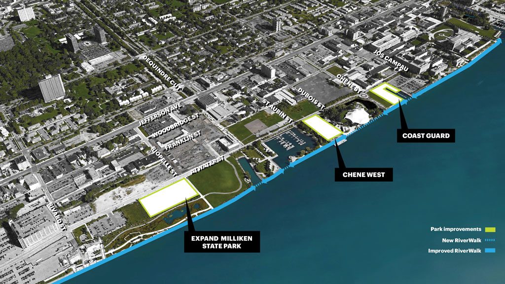
New Parks + Waterfront Improvements. East Riverfront Renderings. Detroit RiverFront Conservancy
- Increasing Community Access to Riverfront: Two new “Dequindre Cut” style greenways will be built along the East Riverfront to connect east side residents to the RiverWalk. The Joseph Campau Greenway, which runs from the Detroit River to Vernor, will receive new lighting, furnishings, paving and landscaping. The Beltline Greenway, located between Belleview and Beaufait, will connect from Kercheval Street to the Detroit River. Together, these greenways provide connectivity to the riverfront for thousands of residents living throughout several eastside neighborhoods.
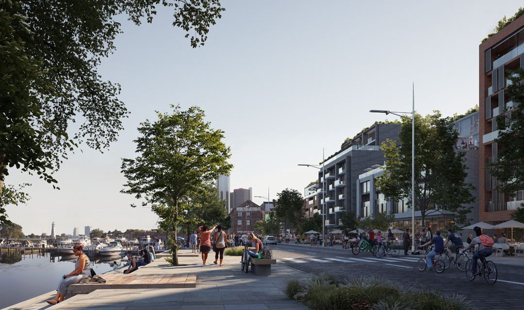
- Streetscape Improvements: E. Jefferson Avenue will be redesigned to be more attractive and bike and pedestrian friendly to provide a more seamless transition between the riverfront and the neighborhoods immediately to the north.
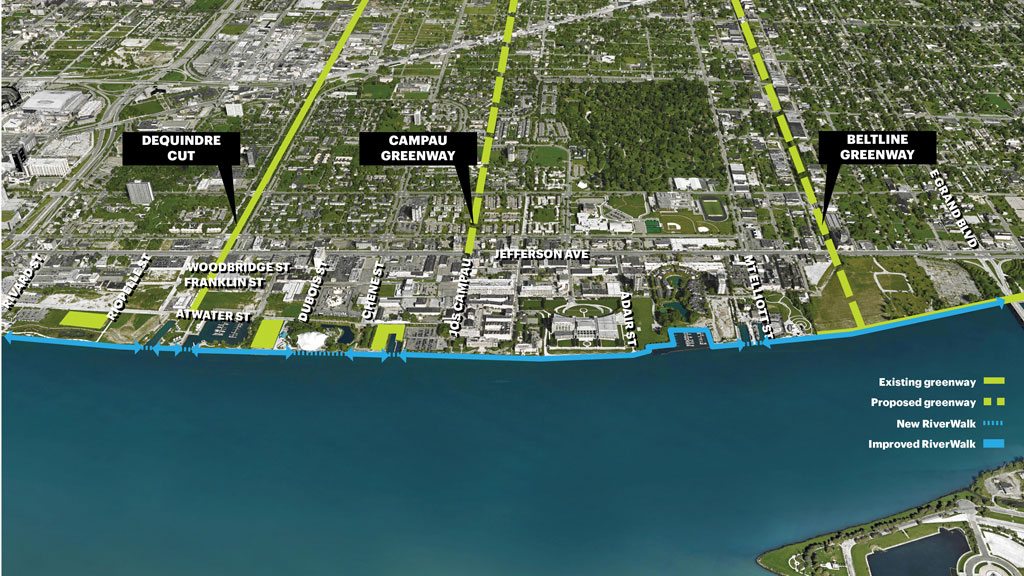
Expand Greenway Connectivity to River. East Riverfront Renderings. Detroit RiverFront Conservancy
Plan is a result of significant community input
This plan came about after intense and extensive interaction with the community – from the general public to key stakeholders. There were a total of four community meetings and workshops held in an open constructive and creative format well over a six month period from March 2016 to the announcement date. Additionally, there were tours by vehicle, boat, bike, and foot; a plethora of interviews, and extensive engagement with various city departments involved in this effort.
“We’ve had tremendous input from the community throughout the planning process,” said Mark Wallace, president & CEO of the Detroit RiverFront Conservancy. “The East Riverfront is a special place for all Detroiters, particularly families and the elderly. This plan builds on the lessons we have learned since opening up the RiverWalk in 2007. The greenway connections and expansions of the park space will significantly improve the riverfront experience for generations to come. And, this plan focuses on achievable goals so people are able enjoy the improvements in the near future.”
Jefferson Avenue streetscape to improve safety, add beauty
In the last five years, Jefferson Avenue between Rivard Street and East Grand Boulevard has been the scene of 1,350 vehicle crashes, 39 pedestrian – vehicular incidents, and nine fatalities of vehicular and pedestrian crashes. Enhanced crosswalks at key intersections and new protected bike lanes will improve safety and mobility options and support local businesses. These improvements will make it easier for residents to cross Jefferson from surrounding neighborhoods north of Jefferson, giving them safe access to the enhanced riverfront.
Next Steps
The plan places particular importance on making significant enhancements to the riverfront that will happen in a relatively short turn-around time.
- Jefferson Avenue improvements will begin in 2017, with the redesign, beautification and implementation from Rivard Street to East Grand Boulevard for a more pedestrian and bike-friendly experience.
- The Detroit RiverFront Conservancy will break ground in 2017 on a promenade that will connect the RiverWalk from Mt. Elliott Park to the Belle Isle Bridge along the 30-acre former Uniroyal site. The RiverWalk extension will also connect to Gabriel Richard Park.
- DEGC, on behalf of the City of Detroit will issue a Request for Proposals (RFP) on March 2 for the Stone Soap building at 1490 Franklin. The RFP will envision an adaptive reuse of the historic structure with a mixed-use development that will increase density along the riverfront. The RFPs will be available at www.degc.org/contractors/new-project-rfps.
Franklin Street Heritage Area Concept. East Riverfront Renderings. Detroit RiverFront Conservancy
DEGC Executive Vice President of Real Estate, Moddie Turay said, “This plan recognizes how the riverfront makes Detroit a special place to live and work and play. We look forward to implementing it as it increases access to the waterfront for everyone, creates new walkable neighborhoods, and supports new investments and jobs that also provide a better quality of life and opportunities for all Detroiters.”
For more information about the revitalization of the East Riverfront, visit yourdetroiteastriverfront.org.
About the Detroit RiverFront Conservancy
The Detroit RiverFront Conservancy is a non-profit organization founded in 2003 with the mission to develop public access to Detroit’s riverfront and serve as an anchor for economic development. As the permanent stewards of the RiverWalk and the Dequindre Cut, the Conservancy is responsible for raising the funds needed for construction, operation, maintenance, security and programming of the public spaces located along the riverfront. The Conservancy’s ultimate vision is to develop five-and-a-half miles of riverfront from the Ambassador Bridge on the west to Gabriel Richard Park, just east of the MacArthur Bridge to Belle Isle. Visit www.detroitriverfront.org for more information.
About Detroit Economic Growth Corporation
Detroit Economic Growth Corporation (DEGC) is a non-profit organization that serves as the lead implementing agency for business retention, attraction and economic development initiatives in the city of Detroit. DEGC is led by a 60-member board comprised of business, civic, labor and community leaders. Its 40 professionals provide staff services for key public authorities that offer tax credits and other forms of financing for projects that bring new jobs or economic activity to the city. Among them: the Downtown Development Authority (DDA), Detroit Brownfield Redevelopment Authority (DBRA) and Economic Development Corporation (EDC). DEGC also provides planning, project management and other services under contract to the city of Detroit. Visit www.degc.org for more information.
